KITCHIN, Thomas (1718-1784).

£400.00

Kitchin’s Enlarged Map of the Roads of England and Wales, with the exact distances by the mile stones, between town and town.

London: engraved & published by Thomas Kitchin, No. 59 Holborn Hill, 30 November 1768..

Apparently unrecorded first edition of this important road map of England and Wales. Thomas Kitchin was born in Southwark, and apprenticed to Emanuel Bowen in 1732, later marrying his daughter, Sarah Bowen, in 1739. Originally based in Clerkenwell, by late 1755 Kitchin was established on Holborn Hill. He had a large output, but is probably most famous for engraving the Mitchell Map of North America, published in February 1755. With Bowen, Kitchin produced The Large English Atlas between 1748-1767, which was a serious attempt to cover England at large scale, while he also published in conjunction with the print seller J. Gapper of New Bond Street Kitchin's Pocket Atlas in 1769. The present map also has Gapper’s name in the imprint, although their joint publishing activities seem to have fizzled out by 1771, which is the earliest date of publication of this map under this title that can be traced (British Library); none earlier can be traced in institutions.

While the title sits within an elaborate architectonic cartouche, the cartography itself strips away relief and a lot of toponyms (counties are numbered and cross-referenced in a key) to produce a clear road map. Kitchin, in a note engraved below the title cartouche, ‘hopes the Commissioners of any New Roads, or other Gentlemen, will transmit … the Names of the several towns … with their distances from each other to him, & they will be immediately inserted, & he will send if desired a proof of the Plate, to satisfy them of his care…’ This same note mentions a smaller edition, which is presumably the general map that appears in the Pocket Atlas. This type of road map is an important indicator of the nascent economic growth of England at this time, with an increased demand from travellers for such maps.

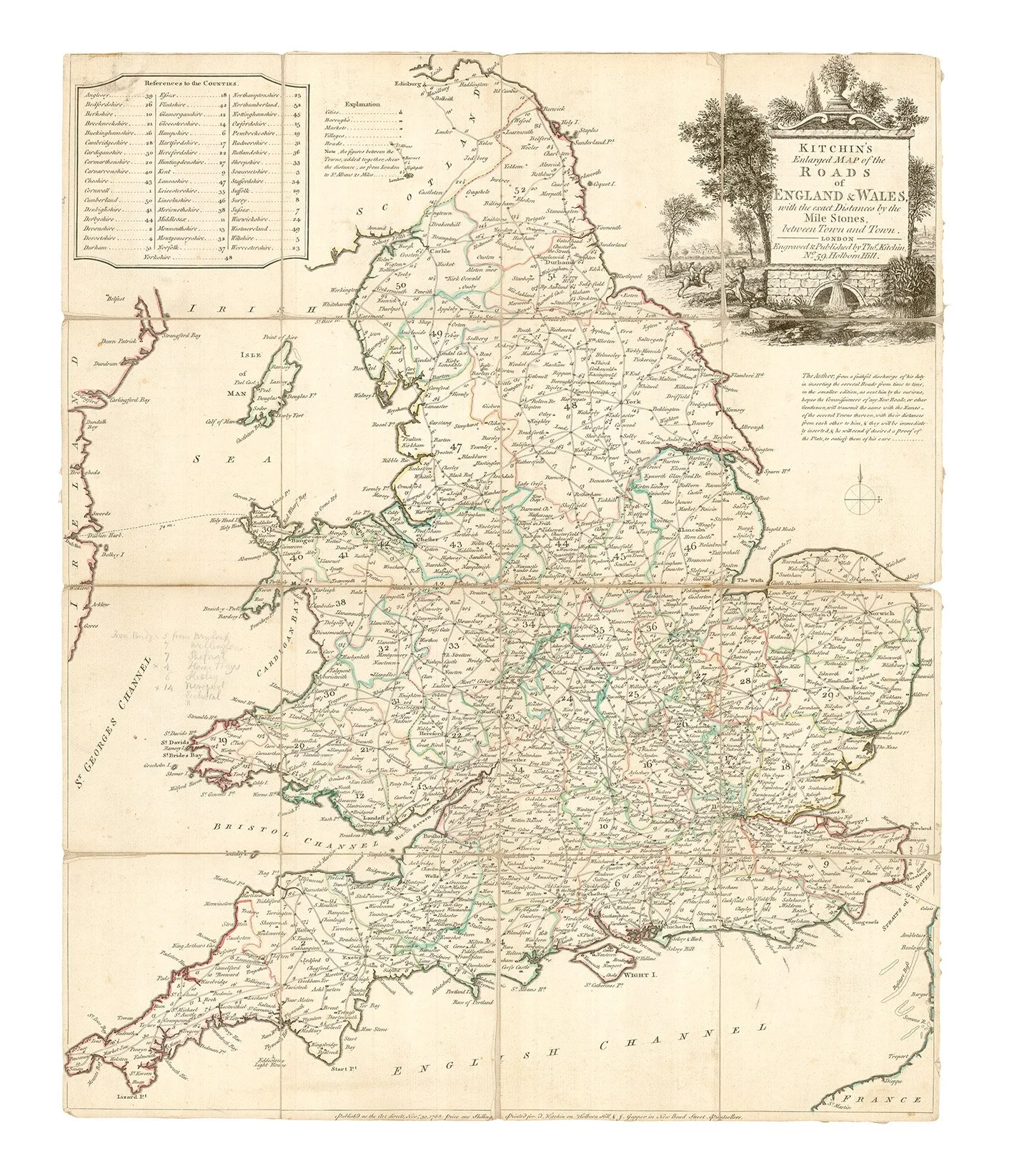
Folding engraved map (543 x 448mm), counties and country borders coloured in outline by a contemporary hand, dissected and mounted on linen, title within elaborate architectonic cartouche set within a landscape with two horsemen in the foreground and a large stately home in the background, scale of approx. 1 inch to 20 miles (1:1,267,200). (Map trimmed just into border and cartouche at head and close to imprint at foot, some light soiling, linen backing with some scattered light staining and worn away along a few folds.) Contained in contemporary marbled slipcase with paper label with ink manuscript ‘England Roads’ on upper cover (soiled and rubbed at extremities with two small holes at lower corners).

Provenance: Murrays of Dollerie, Crieff, Perthshire (no sign of provenance, but pencilled notes on mileage in Irish Sea in an early hand).