BOWLES, John (1702–1771)

£600.00

The London Directory, or a new & improved plan of London, Westminster, and Southwark; with the adjacent country, the new buildings, the new roads, and the late alterations by opening of new streets & widening of others.

London: printed for John Bowles at No. 13 in Cornhill, 1769.

Unrecorded copy of the earliest known edition of Bowles’ map of London. John Bowles was a prominent London map and print publisher active in the 18th century. As part of the influential Bowles family firm that operated from around 1714 to 1832, he produced a wide range of maps, atlases, and prints, and his works are considered important documentation of urban and geographic development in Britain during this period.

The present work is a relatively small-format engraved map, and is a typical example of the practical, accessible maps that were increasingly in demand as London expanded in the late 18th century. The administrative boundary of the City of London is highlighted in red, with its buildings more lightly shaded than those in the City of Westminster, Southwark or the East End. The physical extension of the urban area north of Oxford Street is documented, while development to the east is starting to meet Mile End Old Town; the City itself is becoming surrounded by development on its northern boundary.

The large seven column ‘Table of References’ beneath the map acts as a key using a lettered grid system, and reflects the growing need for a navigational aid in a rapidly growing and sprawling metropolis.

No copy of this map can be traced in institutions. The earliest version we have been able to trace is a 1775 edition in the Bodleian; the British Library’s earliest edition is 1781.

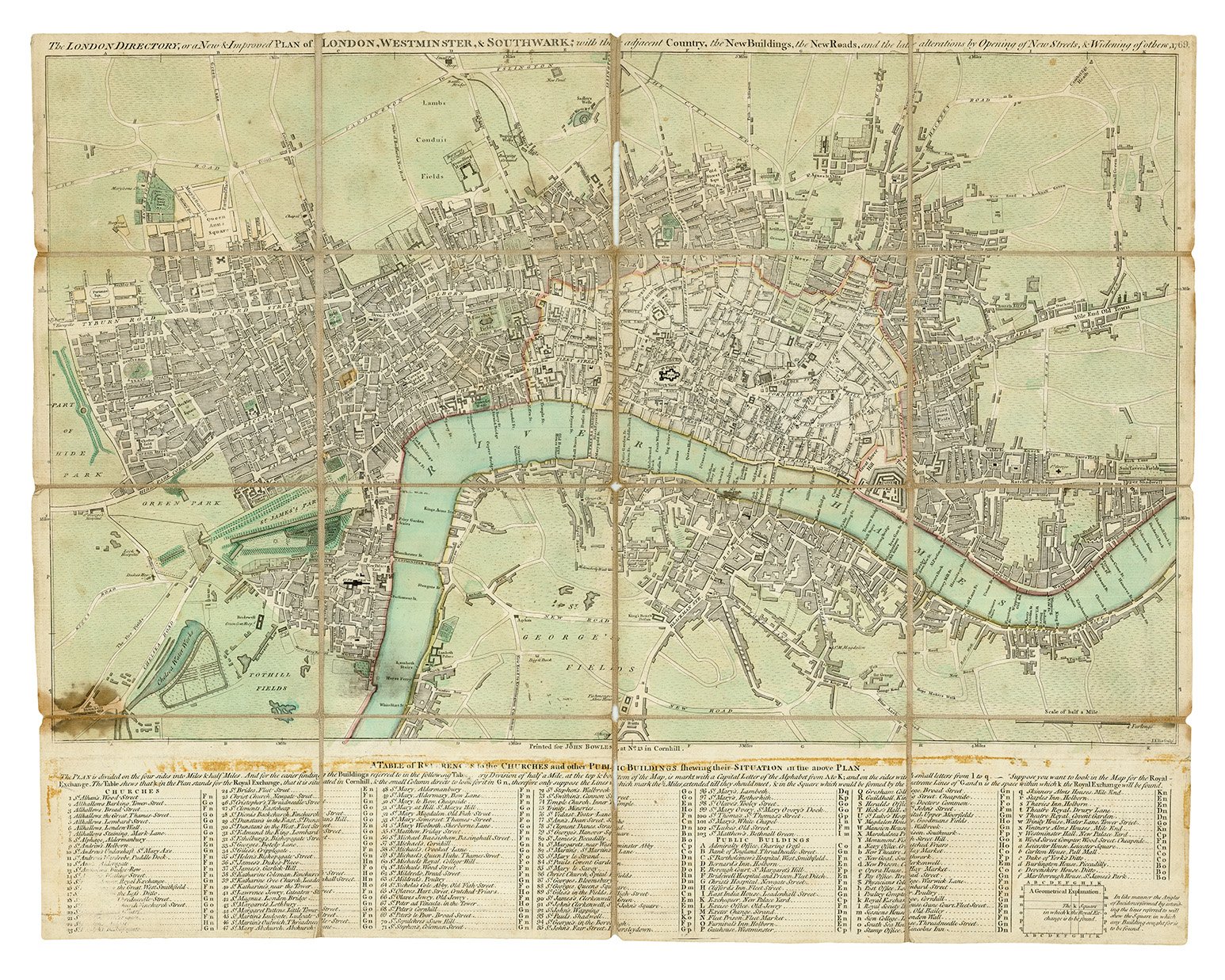
Folding engraved map (417 x 530mm) by J. Ellis, coloured by a contemporary hand, dissected and mounted on 2 pieces of linen stitched together by a contemporary hand, covering from Tyburn Turnpike in the west to Upper Shadwell in the east, and Islington in the north to Newington Butts in the south, ‘Table of References to the churches and other public buildings’ in seven columns beneath, scale of 4 inches to 1 mile (1:15,840). (Map with some soiling and some scattered light staining, abrasion to first column and to title of Table of References with associated loss of text, linen backing worn away along a few folds.) Contained in contemporary marbled paper-covered slipcase with manuscript label (soiled and rubbed at extremities).

Provenance: Murrays of Dollerie, Crieff, Perthshire (no sign of provenance, but ‘Plan of London 1769’ inscribed in ink by a contemporary hand to slipcase).